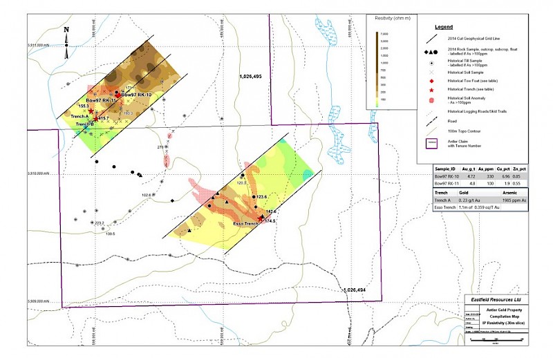
Gold mineralization was first discovered on the property in 1981 by Esso Minerals while following up a government regional geochemical survey. There are two targets on the property.
The first target, called Antler, contains a rubbly outcrop of pyritic, iron carbonate altered volcanic rock returned an assay of 0.359 oz/ton (12.3 g/t) gold across a 1.1 m sample width associated with elevated arsenic. A soil sampling grid over this area outlined a 500 m long arsenic anomaly with the mineralized outcrop at the south end of the anomaly. This work was not followed up. Another discovery of mineralization was made by a prospector in 1997 and is approximately 1.5 km northwest of the Esso discovery. Float boulders were located along a road cut. Two grab samples were taken with the following analytical results: 97-RK10: 4.72 g/t Au, 330 ppm As, 6.96% Cu, 0.85% Zn; and 97RK11: 4.80 g/t Au, 100 ppm As, 1.90% Cu, 0.55% Zn. Subsequent soil and stream geochemical sampling indicated a broad area of elevated gold and arsenic values. A hand trench on one soil anomaly uncovered a 6.0 m long outcrop of faulted, Fe-carbonate altered rock with a zone of quartz-carbonate veining across 2.0 m of the trench. A sample across one metre of the veining returned 0.23 g/t Au, 1985 ppm As, 46 ppm Cu and 84 ppm Zn. No detailed geophysical surveying or drill testing has been completed on this extensive area of anomalous geochemical sampling.
The second target, called 14 Mile Creek, is located where massive sulphide float boulders were discovered by a prospector in August 1996. He outlined an area of 150 m by 300 m in which he located numerous ferricrete encrusted boulders many of which had massive sulphide cores of fine-grained pyrite with lesser chalcopyrite. Cobbles and boulders of fine-grained massive magnetite were also found at this site.
Soil and stream sediment geochemical sampling was carried out in a sporadic manner and did define an area of anomalous arsenic in the vicinity of the float boulders; gold was not analysed in this sampling. In 1987 Eureka Resources Inc. undertook EM geophysical surveys over a portion of the property on a reconnaissance scale and outlined three linear anomalies one of which was 300 m in length and open ended. No further work has been undertaken on the property. The large area of the mineralized boulders indicates a good potential for discovering significant mineralization in bedrock by applying exploration methods that will penetrate the overburden.